Hurricane Erin Captured in Stunning Footage from ISS Camera
A camera on the International Space Station (ISS) captured live video of Hurricane Erin over the Atlantic Ocean. This happened on Thursday, August 21, 2025. It’s a great example of modern space technology.
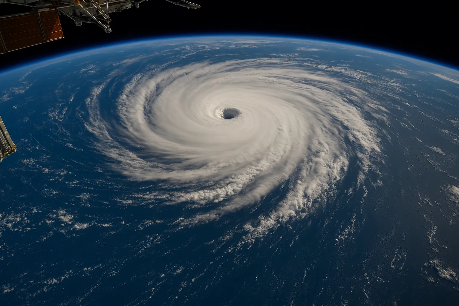
The Sen SpaceTV-1 camera system, on the ISS in low Earth orbit, captured clear footage. It showed Erin, a large hurricane, moving north of the Caribbean and along the U.S. East Coast. Sen’s livestreamed images offer unique real-time views of the storm’s structure and movement.
Authorities warn that Erin has weakened from its peak as a Category 5 hurricane. However, it still poses serious hazards:
- Severe surf and rip currents are likely along the U.S. East Coast. This includes areas from North Carolina to New Jersey.
- Mandatory evacuations are still in place for Hatteras Island and Ocracoke Island in North Carolina’s Outer Banks.
- Erin is expected to pass between Bermuda and the East Coast by Friday. Then, it will turn toward Atlantic Canada.
NASA shared extra ISS footage of Erin’s quickly growing eyewall and wide convective bands. Meteorologists say Erin strengthened from Category 1 to Category 5 in just 24 hours over the weekend. Then, it weakened a bit as it hit cooler waters and faced more wind shear.
The Sen SpaceTV-1 mission went to the ISS in 2024. It started streaming to the public in December. The mission makes about 16 Earth orbits each day. Its constant high-definition views are crucial for tracking the weather, responding to disasters, and engaging the public.
Hurricane Erin is heading northeast. Space-based cameras, like Sen SpaceTV-1, along with regular satellites, will gather vital data. This will aid forecasters and emergency managers as they tackle the Atlantic hurricane season.
Categories
Autos and vehicles Beauty and fashion Business and finance Climate Entertainment Food and drink Games Health Hobbies and leisure Jobs and education Law and government Other Politics Science Shopping Sports Technology Travel and transportationRecent Posts
Tags
Archives
08/19/2025 (3) 08/20/2025 (40) 08/21/2025 (27) 08/22/2025 (22) 08/23/2025 (4) 08/24/2025 (21) 08/25/2025 (30) 08/26/2025 (24) 08/27/2025 (29) 08/28/2025 (16) 08/29/2025 (9) 08/30/2025 (13) 08/31/2025 (17) 09/01/2025 (167) 09/02/2025 (124) 09/03/2025 (149) 09/04/2025 (112) 09/05/2025 (72) 09/06/2025 (169) 09/07/2025 (162) 09/08/2025 (150) 09/09/2025 (176) 09/10/2025 (194) 09/11/2025 (194) 09/12/2025 (186) 09/13/2025 (207) 09/14/2025 (159) 09/15/2025 (175) 09/16/2025 (198) 09/17/2025 (196) 09/18/2025 (196) 09/19/2025 (207) 09/20/2025 (129) 09/21/2025 (4)