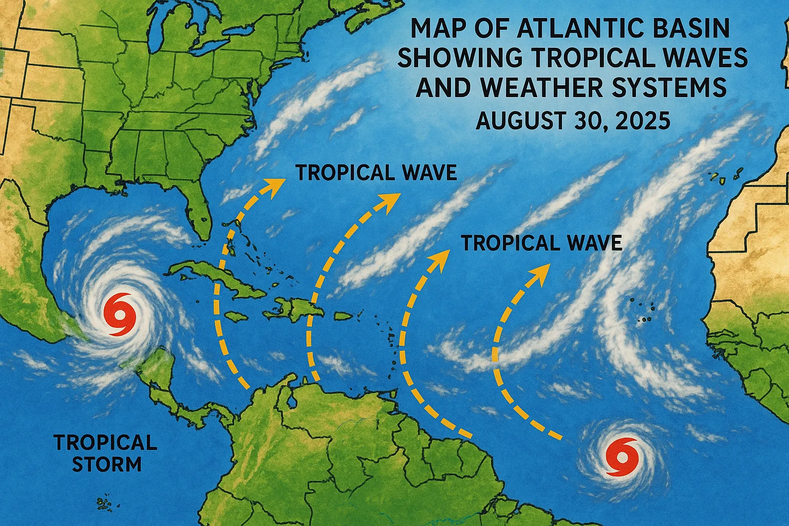
Atlantic Hurricane Season Update - August 30, 2025

Today’s key highlights:
- The 2025 Atlantic hurricane season has produced six named storms, one hurricane, and one major hurricane, with an accumulated cyclone energy (ACE) of 39.3 units-15 percent above the 1991-2020 climatological average.
- The National Hurricane Center (NHC) issued its 8 AM EDT Tropical Weather Outlook, monitoring a tropical wave forecast to emerge off Africa on Sunday with a low (< 1 percent) chance of development in the next 48 hours and 30 percent over seven days.
- The Tropical Weather Discussion details three tropical waves in the basin today, though none show immediate development and convection remains limited.
Season Statistics as of 09 UTC August 30, 2025
| Metric | 2025 Season | 1991-2020 Normal | Difference |
|---|---|---|---|
| Named Storms | 6 | 6 | 0 |
| Hurricanes | 1 | 2 | −1 |
| Major Hurricanes (Category 3+) | 1 | 0.8 | +0.2 |
| Accumulated Cyclone Energy (ACE, x10⁴ kt²) | 39.3 | 34.2 | +15 percent |
| Total Direct Deaths | 0 | 56 | −56 |
| Total U.S. Damage (USD, millions) | 0 | 4,000 | −4,000 |
NHC Tropical Weather Outlook
At 8 AM EDT, the NHC highlighted:
- Eastern Tropical Atlantic: A tropical wave is forecast to emerge off Africa on Sunday. Environmental conditions could support slow development as it moves west-northwest at ~15 mph.
- Formation chance through 48 hours: near 0 percent
- Formation chance through 7 days: 30 percent
No other areas show immediate tropical cyclone formation potential.
Tropical Weather Discussion
Based on satellite imagery and surface analyses through 10 UTC:
- Tropical Waves:
- Eastern Atlantic wave near 80°W south of 20°N (no significant convection)
- Central Atlantic wave along 60°W south of 17°N (scattered moderate convection south of 12°N, west of 55°W)
- Western Caribbean wave near 84°W south of 19°N (scattered moderate to strong convection west of 82°W)
- Monsoon Trough/ITCZ: Scattered moderate convection from 03°N-14°N east of 20°W, and 05°N-10°N between 31°W-45°W.
- Gulf of Mexico & Caribbean: A stationary front across the northern Gulf Coast brings isolated thunderstorms; fresh to strong easterly trades maintain moderate to rough seas in the central Caribbean.
- Subtropical Atlantic: A ridge north of the basin keeps mild conditions, while a 1,029 mb high between the Azores and Nova Scotia induces fresh easterlies over the tropical Atlantic.
Outlook Through the Weekend
- The tropical wave in the eastern Atlantic will move into the central tropical Atlantic early next week with little change in development potential.
- Trade wind and sea surface temperature patterns remain slightly favorable for tropical activity through September’s peak.
- No active tropical cyclones are expected to form imminently; interests across the Lesser Antilles and Caribbean should continue routine monitoring of NHC updates.
Stay tuned for further advisories and updates from the National Hurricane Center.
Categories
Autos and vehicles Beauty and fashion Business and finance Climate Entertainment Food and drink Games Health Hobbies and leisure Jobs and education Law and government Other Politics Science Shopping Sports Technology Travel and transportationRecent Posts
Florida State Coach Mike Norvell’s Big Day in Tallahassee
YouTube TV Missing from Google TV Live Tab; Google Acknowledges Issue
Blizzard Files Copyright Infringement Lawsuit Against Turtle WoW
Former President Clinton Spotted with Portable Defibrillator, Renewing Health Concerns
Shapovalov Frustrated by Foot Fault in US Open Third-Round Exit
Denis Shapovalov Loses in Controversial US Open Third Round Clash
Major Verizon Outage Disrupts Service Nationwide on August 30, 2025
Rep. Maxine Waters Calls for Invocation of 25th Amendment Against President Trump
President Trump Dispels Health Rumors with Public Golf Outing; White House Reiterates “Excellent Health”
Verizon Suffers Major Nationwide Outage, Leaving Thousands of Users in “SOS Mode”
Guillermo del Toro’s “Frankenstein” Makes Grand Debut at Venice Film Festival on Mary Shelley’s Birthday
Polish Businessman Piotr Szczerek Addresses Global Backlash Over US Open Hat Incident
Old Dominion University Athletics Launches 2025 Season on the Road
Verizon Experiences Widespread Service Outage on August 30, 2025
Rookidee Community Day Takes Flight Across the Globe
Justice Department Paralegal Elizabeth Baxter Dismissed for Gesturing at National Guard
Michigan News Summary - August 30, 2025
Alix Earle Shines at “Happy Gilmore 2” Premiere on August 30, 2025
Netflix’s “Unknown Number: The High School Catfish” Sparks Nationwide Conversation
Alabama Kicks Off 2025 Football Schedule with Road Opener Against Florida State
Tags