Hurricane Kiko Forecast: Category 4 Storm Headed Toward Hawaii
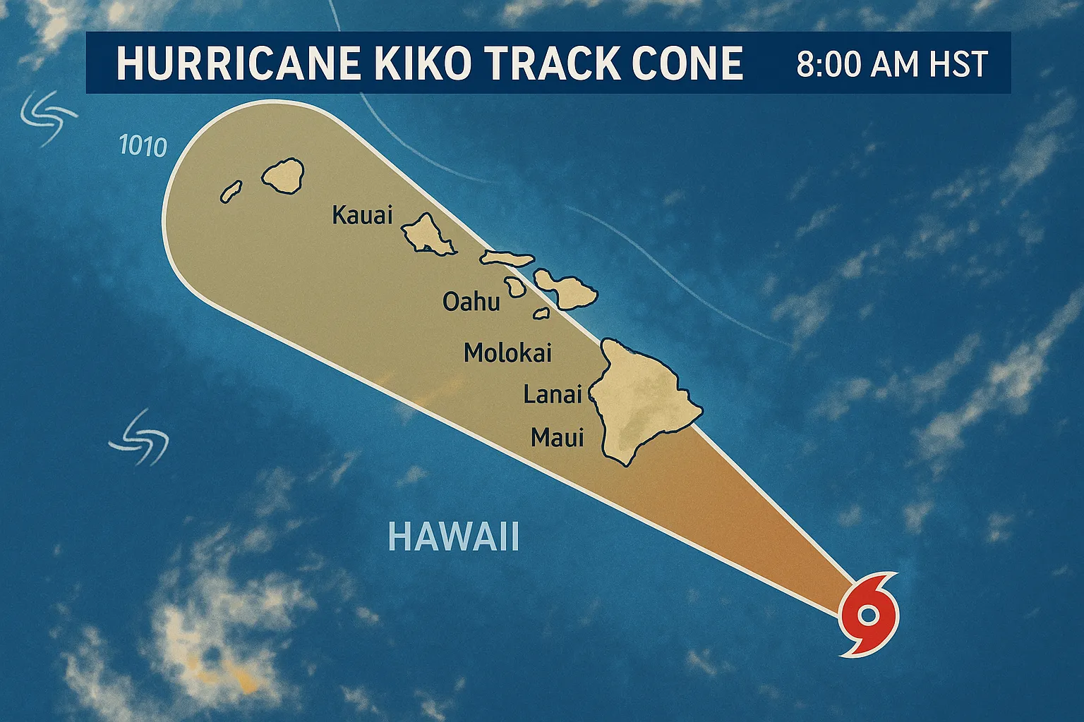
Lead Hurricane Kiko, a fierce Category 4 system packing 140 mph winds, is advancing west-northwest in the eastern Pacific and is forecast to enter the central Pacific basin late tonight, with Hawaiian impacts possible early next week.
Nut Graf Interests across Hawaii should monitor Kiko’s track as swells are set to arrive Sunday and build to life-threatening heights by Monday. Although exact impacts remain uncertain, preparations for heavy surf, rip currents and gusty winds are prudent.
Current Status
- Intensity: 140 mph sustained winds, annular structure typical of powerful hurricanes
- Position: moving west-northwest at 10 mph under the influence of a subtropical ridge and nearby upper-level low
- Forecast Track: crossing into the central Pacific late tonight or early Saturday; a slight leftward deviation could bring it closer to the Big Island
Expected Hazards
- Surf and Rip Currents: Swells will begin reaching east-facing shores of the Big Island and Maui by Sunday, peaking Monday through midweek with potentially life-threatening surf and rip currents
- Wind and Rain: If the track shifts northward, rain bands and gusty winds could affect windward areas; exact land impacts remain too early to determine
- Marine Conditions: High surf advisories possible as swell energy arrives; mariners should heed National Weather Service advisories
Forecast Evolution
- Next 12-24 Hours: Kiko should maintain Category 4 strength over 26-27 °C waters with light shear
- Beyond 48 Hours: Cooler waters, dry air and increasing shear (30+ knots) will likely induce rapid weakening, though annular structure may prolong intensity
- Model Guidance: Official forecasts hold above consensus guidance into the weekend, trending toward gradual weakening early next week
Recommendations
- Monitor Updates: Follow the National Hurricane Center advisories and local National Weather Service statements for watches or warnings.
- Prepare Early: Secure loose objects, check coastal signage and heed rip current warnings at beaches.
- Stay Informed: Swell arrival times and intensity will hinge on Kiko’s precise track; residents and visitors should stay alert.
Subheadings for Online Scanning
- Storm Details: Category 4, 140 mph, west-northwest at 10 mph
- Timeline: Central Pacific entry late Sept. 6; swells begin Sunday, peak Monday-Wednesday
- Impacts: Life-threatening surf, possible gusty winds, localized heavy rain
- Action Items: Monitor NHC advisories, prepare shoreline and property
This concise forecast emphasizes Kiko’s projected path toward Hawaii, potential hazards and necessary precautions, structured for quick online readability.
Categories
Autos and vehicles Beauty and fashion Business and finance Climate Entertainment Food and drink Games Health Hobbies and leisure Jobs and education Law and government Other Politics Science Shopping Sports Technology Travel and transportationRecent Posts
Tags
Archives
08/19/2025 (3) 08/20/2025 (40) 08/21/2025 (27) 08/22/2025 (22) 08/23/2025 (4) 08/24/2025 (21) 08/25/2025 (30) 08/26/2025 (24) 08/27/2025 (29) 08/28/2025 (16) 08/29/2025 (9) 08/30/2025 (13) 08/31/2025 (17) 09/01/2025 (167) 09/02/2025 (124) 09/03/2025 (149) 09/04/2025 (112) 09/05/2025 (72) 09/06/2025 (169) 09/07/2025 (162) 09/08/2025 (150) 09/09/2025 (176) 09/10/2025 (194) 09/11/2025 (194) 09/12/2025 (186) 09/13/2025 (207) 09/14/2025 (159) 09/15/2025 (175) 09/16/2025 (198) 09/17/2025 (196) 09/18/2025 (196) 09/19/2025 (207) 09/20/2025 (129) 09/21/2025 (4)