Storm Gabrielle Forms in Central Atlantic, Heads Toward Bermuda but Bypasses U.S.
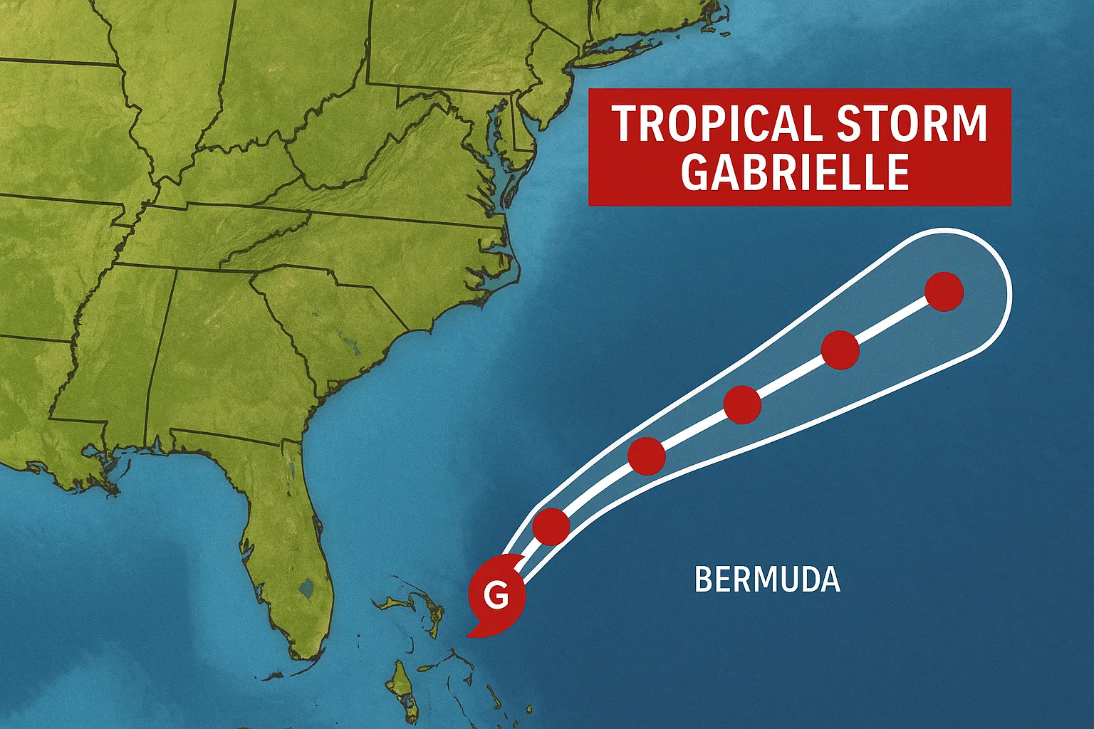
Lead: Tropical Storm Gabrielle emerged Wednesday morning about 1,100 miles east of the Leeward Islands, the seventh named storm of the 2025 Atlantic season, moving north-northwest and forecast to skirt U.S. shores.
Nut Graf: Ending a nearly three-week lull in tropical activity, Gabrielle’s formation underscores an uptick in Atlantic storms during the peak season. While U.S. landfall remains unlikely, interests in Bermuda should monitor the system’s gradual intensification.
Formation and Current Status
- Tropical Depression Seven intensified into Tropical Storm Gabrielle Wednesday morning, with sustained winds near 45 mph and gusts higher.
- The center is elongated, hindered by southwesterly wind shear and dry air, keeping its strongest convection east of the core.
Forecast and Anticipated Impacts
- Gabrielle is expected to experience minimal strengthening over the next 48 hours due to unfavorable shear, then gradually intensify, potentially reaching hurricane strength by Sunday.
- Forecast track takes the storm northwestward, well east of the U.S. mainland, with no watches or warnings in effect for Florida or other U.S. states.
- Bermuda is inside the extended cone of uncertainty; outer rainbands and elevated surf are possible early next week.
Seasonal Context
- Gabrielle marks the seventh storm in a season projected to yield 13-18 named storms, of which five to nine may become hurricanes.
- This formation occurs after an unusually quiet peak period, with only one prior hurricane (Erin) making oceanic circulation patterns favorable for Gabrielle’s development.
- Another tropical wave off Africa merits monitoring but poses low development odds over the next week.
Key Points to Watch
- Potential intensification into a Category 1 hurricane by late weekend.
- Shift in steering currents that will determine Gabrielle’s proximity to Bermuda.
- Ongoing satellite and scatterometer observations for center reformation and wind field changes.
Tropical interests should revisit official National Hurricane Center advisories for updates.
Categories
Autos and vehicles Beauty and fashion Business and finance Climate Entertainment Food and drink Games Health Hobbies and leisure Jobs and education Law and government Other Politics Science Shopping Sports Technology Travel and transportationRecent Posts
Gunman Arrested After Country Club Wedding Shooting in Nashua
Trump, Vance Honor Charlie Kirk at Massive Arizona Funeral
DOJ Closes Bribery Probe into Border Czar Tom Homan
Bad Bunny Concludes Puerto Rico Residency with Star-Studded Amazon Livestream
Multiple Shot, Including One Fatality, at Sky Meadow Country Club
Bad Bunny Delivers Historic “Una Más” Livestream Finale from Puerto Rico
‘28 Years Later’ Arrives on Netflix, Three Months After Theatrical Debut
Cyberattack Snarls Check-In Systems at Major European Airports
Premier League Sees Upsets as Liverpool Edges Everton
Chelsea’s Adarabioyo Drafted In After Sanchez Sent Off at Old Trafford
Superman Premieres on HBO Linear Tonight as Streaming Hit
Southern Skies to Darken: Partial Solar Eclipse Looms Tomorrow
Venus’s Square with Uranus Fuels Independence in Today’s Horoscopes
Dublin Airport’s Terminal 2 Evacuated and Reopened After Security Alert
Tell me what happened today 09/20/2025: “tcu” and write it in news format in English.
Clemson University Dismisses Three Employees After Free Speech Controversy
Braun Strowman Unveils USA Network Series and Horror Sequel Role
Noem Launches National ICE Initiative via Social Media
Binance Implements Margin and Leverage Adjustments on September 20, 2025
Spurs Salvage Late Draw at Brighton
Tags
Archives
08/19/2025 (3) 08/20/2025 (40) 08/21/2025 (27) 08/22/2025 (22) 08/23/2025 (4) 08/24/2025 (21) 08/25/2025 (30) 08/26/2025 (24) 08/27/2025 (29) 08/28/2025 (16) 08/29/2025 (9) 08/30/2025 (13) 08/31/2025 (17) 09/01/2025 (167) 09/02/2025 (124) 09/03/2025 (149) 09/04/2025 (112) 09/05/2025 (72) 09/06/2025 (169) 09/07/2025 (162) 09/08/2025 (150) 09/09/2025 (176) 09/10/2025 (194) 09/11/2025 (194) 09/12/2025 (186) 09/13/2025 (207) 09/14/2025 (159) 09/15/2025 (175) 09/16/2025 (198) 09/17/2025 (196) 09/18/2025 (196) 09/19/2025 (207) 09/20/2025 (129) 09/21/2025 (4)