Hurricane Erin (2025): A Comprehensive Analysis
Key Takeaway: Hurricane Erin quickly intensified into a Category 5 storm early in the 2025 Atlantic season. This highlights the rising impact of climate-driven ocean warming. Erin didn’t hit land directly, but it still caused major issues. Its strong winds, heavy rain, and rough surf affected the northern Leeward Islands, Puerto Rico, and the wider Atlantic area.
1. Meteorological History
Hurricane Erin started as a tropical wave off Africa’s west coast in early August 2025. It started as a tropical depression on August 11. Then, on August 12, it became Tropical Storm Erin. This happened about 280 miles west of the Cabo Verde Islands. Erin moved steadily west-northwest at 15–18 mph due to a subtropical ridge. She faced better conditions, with sea surface temperatures over 28 °C and low vertical wind shear. These factors allowed for rapid intensification.
- By 11 a.m. EDT on August 15, Erin reached hurricane status with sustained winds of 75 mph (Category 1).
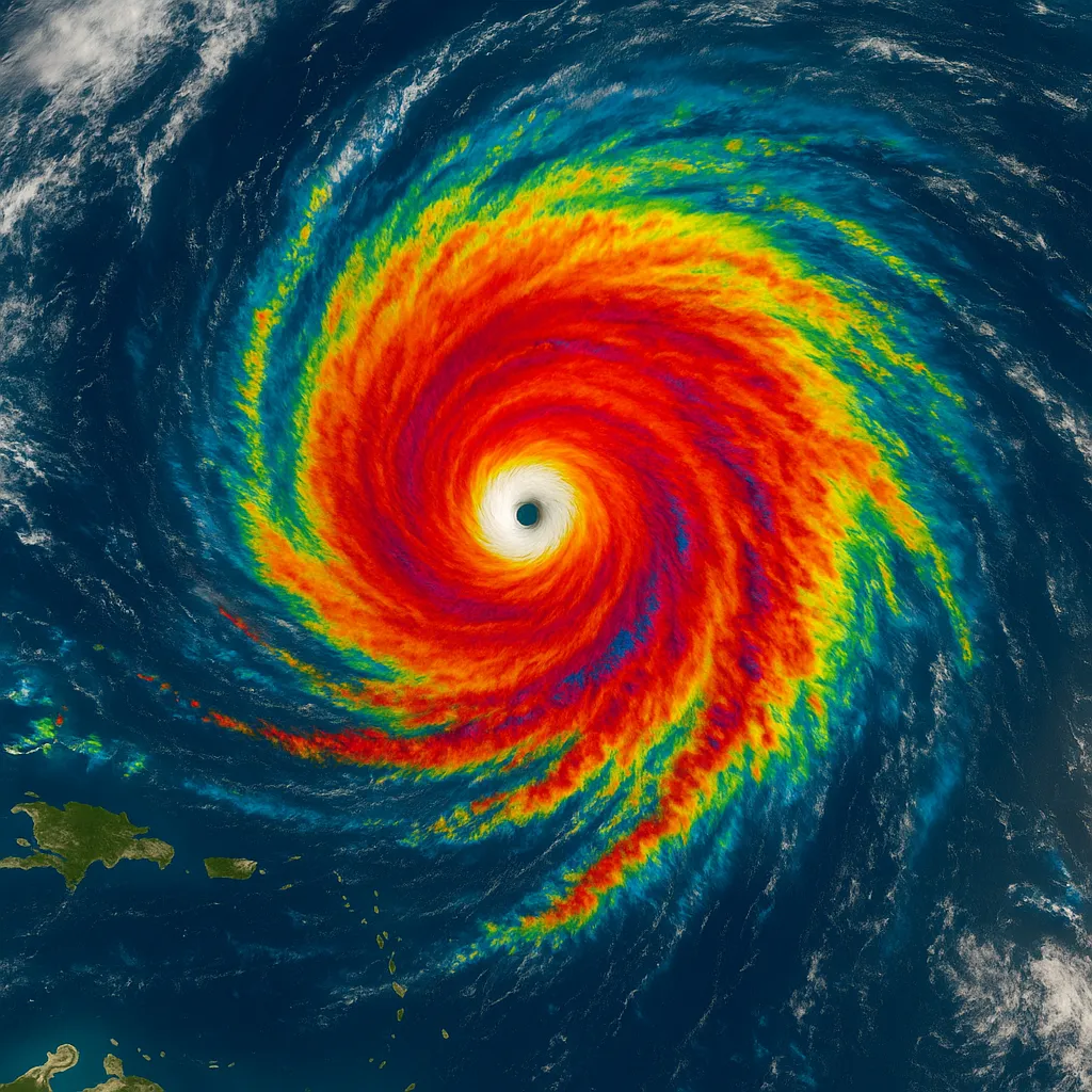
- In the following 24 hours, Erin intensified fast. It became a Category 5 storm, with peak winds near 160 mph. By 2 p.m. AST on August 16, the central pressure fell to 915 mb.
- This shows an increase of at least 85 mph in under 24 hours. Erin is now one of the fastest-strengthening storms ever recorded. This is especially impressive since it happens before the peak season in September.
- After reaching Category 5 strength, Erin went through eyewall replacement cycles. This led to changes between Category 4 and Category 5. By early August 17, Erin weakened to Category 3. Sustained winds were at 125 mph.
2. Track and Forecast
Erin moved west-northwest across the open Atlantic. Mid-level ridging to the north guided its path. Forecasts from the U.S. National Hurricane Center projected:
- On August 16–17, the hurricane made a slight westward shift over the northern Leeward Islands and Puerto Rico. This change kept its core offshore.
- Erin will make a northward turn late Sunday into Monday. It will hit a trough in the western Atlantic. This will push it northeast between Bermuda and the U.S. East Coast by mid-week.
- The chance of a direct U.S. landfall is low. Still, hazardous surf and rip currents are likely along the East Coast.
3. Intensity Timeline
| Date & Time (UTC) Intensity & Winds Central Pressure Notes Source | |
|---|---|
| August 15, 15:00 (11 a.m. EDT) d> | Category 1 (75 mph) – First hurricane of the season yle=“text-align: left;"> |
| August 16, 11:20 AST Category 5 (160 mph) 917 mb Catastrophic peak strength =“text-align: left;"> | |
| August 16, 14:00 AST Category 5 (160 mph) 915 mb Maximum intensification observed style=“text-align: left;"> | |
| August 16, late Category 4 (140 mph) – First weakening after peak =“text-align: left;"> | |
| August 17, 08:00 AST Category 3 (125 mph) – Downgraded but still a major hurricane d> |
4. Impacts
4.1 Northern Leeward Islands & Virgin Islands
- Wind: Outer rainbands generated gusts up to tropical-storm force. Tropical storm watches were issued for St. Martin, St. Barthelemy, and Sint Maarten.
- Rainfall: Some areas received 2–6 inches, while a few saw up to 8 inches. This resulted in flash flooding, urban flooding, and landslides.
4.2 Puerto Rico
- Wind: Sustained hurricane-force gusts damaged power infrastructure; over 159,000 customers lost electricity.
- Rainfall: Radar shows 2–4 inches in northern Puerto Rico. Some areas could see 6–8 inches, leading to flood watches through Monday.
- Surf & Rip Currents: Life-threatening surf affected coastlines for days after, prompting beach closures.
4.3 Turks and Caicos & Southeastern Bahamas
- Tropical Storm Conditions: Warnings were issued as outer bands moved in on August 17–18. Gusty winds and heavy rain are on the way.
4.4 U.S. East Coast & Bermuda
- **Offshore Hazards:** Erin stayed offshore, but swells and rip currents hit the Carolinas, New England, and Atlantic Canada by mid-week.
5. Rapid Intensification and Climate Context
Erin’s record-setting intensification—a rise of 85 mph in about 24 hours—shows the trend of rapid intensification in a warming Atlantic. Studies attribute this to:
- Elevated sea surface temperatures, providing abundant latent heat.
- Enhanced mid-level moisture, reducing entrainment of dry air.
- Lower vertical wind shear, allowing storms to vertically align and intensify more efficiently.
Erin was one of just 43 Category 5 hurricanes in the Atlantic. It formed early in the season, which shows how climate change is shifting our baselines.
6. Preparation and Response
- National Hurricane Center Advisories: Local authorities and emergency managers relied on timely updates and visual products.
- Shelter Activations: Over 200 FEMA workers were stationed in Puerto Rico. A total of 367 shelters were set up.
- **Port Closures:** The U.S. Coast Guard closed ports in St. Thomas and St. John. Six seaports in Puerto Rico are also closed to incoming vessel traffic.
- **Public Advisories:** Flash flood and high surf warnings are out from the National Weather Service for islands at risk.
7. Conclusions
Hurricane Erin’s evolution in August 2025 highlighted several critical lessons:
- Need for Early Readiness: Rapid intensification events need quick changes to forecasts and readiness plans, even if landfall doesn’t seem likely.
- **Improved Forecasting Tools:** Advanced ocean and weather monitoring, such as airborne reconnaissance and detailed satellite images, are key to capturing the swift changes in storm dynamics.
- **Climate Adaptation:** Coastal communities need to strengthen their resilience. As hurricanes intensify quickly, they face greater risks from severe storms and related dangers.
Erin didn’t destroy large land populations, but it highlighted how fierce Atlantic hurricanes are becoming. This shift is fueled by a warming climate. It shows the need for better forecasting, early warnings, and stronger infrastructure.
Categories
Autos and vehicles Beauty and fashion Business and finance Climate Entertainment Food and drink Games Health Hobbies and leisure Jobs and education Law and government Other Politics Science Shopping Sports Technology Travel and transportationRecent Posts
Tags
Archives
08/19/2025 (3) 08/20/2025 (40) 08/21/2025 (27) 08/22/2025 (22) 08/23/2025 (4) 08/24/2025 (21) 08/25/2025 (30) 08/26/2025 (24) 08/27/2025 (29) 08/28/2025 (16) 08/29/2025 (9) 08/30/2025 (13) 08/31/2025 (17) 09/01/2025 (167) 09/02/2025 (124) 09/03/2025 (149) 09/04/2025 (112) 09/05/2025 (72) 09/06/2025 (169) 09/07/2025 (162) 09/08/2025 (150) 09/09/2025 (176) 09/10/2025 (194) 09/11/2025 (194) 09/12/2025 (186) 09/13/2025 (207) 09/14/2025 (159) 09/15/2025 (175) 09/16/2025 (198) 09/17/2025 (196) 09/18/2025 (196) 09/19/2025 (207) 09/20/2025 (129) 09/21/2025 (4)